• Login
  • Sign Up
Member Area
  • Login
  • Sign Up
 English
    • Afrikaans formal
    • Afrikaans informal
    • Arabic
    • Azerbaijan
    • Brazilian
    • Bulgarian
    • Catalan
    • Chinese simplified
    • Chinese traditional
    • Croatian
    • Czech
    • Danish
    • Dutch
    • English
    • Estonian
    • Finnish
    • French
    • Georgian
    • German
    • Greek
    • Hebrew
    • Hungarian
    • Icelandic
    • Indonesian
    • Italian
    • Japanese
    • Latvian
    • Lithuanian
    • Malaysian
    • Norwegian
    • Persian
    • Polish
    • Portuguese
    • Romanian
    • Russian
    • Serbian
    • Slovakian
    • Slovenian
    • Spanish
    • Swedish
    • Thai
    • Turkish
    • Ukrainian
    • Vietnamese
VideotonStock
Your Shopping Cart is empty.
  • Files

    Stock

    • Photo
    • Video

    Special offer

    • Collections
    • Packages
    • Lightboxes

    Licenses

    • Royalty free
    • Rights managed
    • Creative
    • Editorial

    Items

    • Most downloaded
    • Featured
    • Most popular
    • New
    • Free
  • Categories

    Browse categories

  • Site info

    Site info

    • About
    • Support
    • Privacy Policy
    • Privacy Policy
    • FAQ
    • Contact Us
    • Contact Us
    • Terms and Conditions
    • Buyer Agreement
    • Seller Agreement

    Customers

    • Users
    • Credits

    Photographers

    • Boby Richards   0
    • Boby Richards   0
    • Videoton1   286

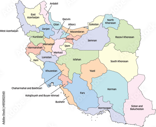
Colorful editable vector political map of Iran, showing its various provinces. Each province is distinctly colored and labeled with its name.

    {PATH}


Download sample
File Details
Published: 2024-07-21 21:07:01.693708 Category: Graphic Resources Type: Vector Model release: No
Share
Contributor: Gary Riegel
ID : 892802560

TitleFilesize
Vector4286x3499


Buy on VideotonStock

Keywords
iran, iranian, middle east, map, islamic, country, vector, editable, kurdistan, azerbaijan, country, asia, administrative, arab, atlas, border, cartography, concept, contour, design, detailed, geography, graphic, illustration, infographic, isolated, land, nation, outline, political, province, region, shape, silhouette, territory


Related items

  • Home
  • About
  • Support
  • Privacy Policy
  • News

Copyright © 2022 Videoton Media Stock