Login
Sign Up
Member Area
Login
Sign Up
English
Afrikaans formal
Afrikaans informal
Arabic
Azerbaijan
Brazilian
Bulgarian
Catalan
Chinese simplified
Chinese traditional
Croatian
Czech
Danish
Dutch
English
Estonian
Finnish
French
Georgian
German
Greek
Hebrew
Hungarian
Icelandic
Indonesian
Italian
Japanese
Latvian
Lithuanian
Malaysian
Norwegian
Persian
Polish
Portuguese
Romanian
Russian
Serbian
Slovakian
Slovenian
Spanish
Swedish
Thai
Turkish
Ukrainian
Vietnamese
Toggle navigation
VideotonStock
Your Shopping Cart is empty.
Files
Stock
Photo
Video
Special offer
Collections
Packages
Lightboxes
Licenses
Royalty free
Rights managed
Creative
Editorial
Items
Most downloaded
Featured
Most popular
New
Free
Categories
Browse categories
Site info
Site info
About
Support
Privacy Policy
Privacy Policy
FAQ
Contact Us
Contact Us
Terms and Conditions
Buyer Agreement
Seller Agreement
Customers
Users
Credits
Photographers
Boby Richards
0
Boby Richards
0
Videoton1
286
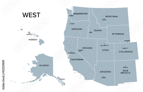
West, census region of the United States of America, gray political map of census region 4, consisting of 13 single states. Map with geographical borders and capitals. Isolated illustration.
{PATH}
Download sample
File Details
Published:
2024-08-21 20:23:47.416904
Category:
Travel
Type:
Vector
Model release:
Yes
Share
Contributor:
Peter Hermes Furian
ID : 932139809
Title
Filesize
Vector
4824x3110
Buy on VideotonStock
Keywords
west
,
western
,
census
,
region
,
us
,
us
,
map
,
state
,
division
,
subdivision
,
silhouette
,
american
,
america
,
capital
,
border
,
boundary
,
geographical
,
group
,
mountain
,
pacific
,
west coast
,
pacific coast
,
california
,
hawaii
,
alaska
,
nevada
,
utah
,
colorado
,
land of enchantment
,
arizona
,
datum
,
classification
,
statistic
,
administrative
,
administration
,
system
,
country
,
mapping
,
atlas
,
overview
,
geography
,
cartography
,
infographic
,
isolated
,
grey
,
illustration
Related items