Login
Sign Up
Member Area
Login
Sign Up
English
Afrikaans formal
Afrikaans informal
Arabic
Azerbaijan
Brazilian
Bulgarian
Catalan
Chinese simplified
Chinese traditional
Croatian
Czech
Danish
Dutch
English
Estonian
Finnish
French
Georgian
German
Greek
Hebrew
Hungarian
Icelandic
Indonesian
Italian
Japanese
Latvian
Lithuanian
Malaysian
Norwegian
Persian
Polish
Portuguese
Romanian
Russian
Serbian
Slovakian
Slovenian
Spanish
Swedish
Thai
Turkish
Ukrainian
Vietnamese
Toggle navigation
VideotonStock
Your Shopping Cart is empty.
Files
Stock
Photo
Video
Special offer
Collections
Packages
Lightboxes
Licenses
Royalty free
Rights managed
Creative
Editorial
Items
Most downloaded
Featured
Most popular
New
Free
Categories
Browse categories
Site info
Site info
About
Support
Privacy Policy
Privacy Policy
FAQ
Contact Us
Contact Us
Terms and Conditions
Buyer Agreement
Seller Agreement
Customers
Users
Credits
Photographers
Boby Richards
0
Boby Richards
0
Videoton1
286
Search
Keywords:
Creator ID:
Type:
Photo
Illustration
Vector
Video
Template
3d
Categories:
Animals
Buildings and Architecture
Business
Drinks
The Environment
States of Mind
Food
Graphic Resources
Hobbies and Leisure
Industry
Landscapes
Lifestyle
People
Plants and Flowers
Culture and Religion
Science
Social Issues
Sports
Technology
Transport
Travel
News
Entertainment
Sport News
Languages:
Brazilan Portuguese - Brazil
English - Canada
French - Canada
Spanish - Mexico
English - United States
English - Belgium
French - Belgium
Dutch - Belgium
Czech - Czech Republic
English - Cyprus
Danish - Danmark
German - Germany
English - Estonia
Spanish - Spain
French - France
French - Marocco
English - Greece
English - Ireland
Italian - Italia
English - Latvia
English - Lithuania
German - Luxembourg
English - Luxembourg
French - Luxembourg
English - Hungary
English - Malta
Dutch - Nederlands
Bokmal Norwegian - Norway
German - Austria
Polish - Poland
Portuguese - Portugal
English - Romania
German - Switzerland
English - Slovenia
Slovakian - Slovakia
French - Switzerland
English - Finland
Swedish- Sweden
Italian - Switzerland
English - United Kingdom
English - Bulgaria
English - Australia
Japanese - Japan
Korean - South Korea
English - New Zealand
Russian - Russia
English - Ukrain
English - Thailand
Orientation:
All
Horizontal
Vertical
square
Color:
Model property release:
All
Yes
No
Duration Video:
All
Up to 10 seconds
Up to 20 seconds
Longer than 30 seconds
Results
(0)
Site
Getty/iStock
Bigstockphoto
Pixabay
Adobe Stock
Relevance
New
Most popular
Most downloaded
Undiscovered
12
24
36
48
96
Auto paging
Menu
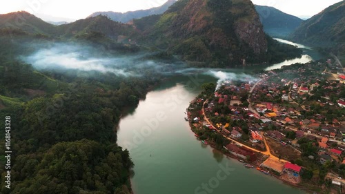
aerial sunset view of Nong Khiaw village in the Luang Prabang Province of northern Laos on the Nam Ou River drone footage travel destination south east Asia
Aerial time lapse above the clouds while sunrise sky. A sea of fog is formed from stratus. Foggy valley mount ridge nature. Tim lapse cloudy formation slow
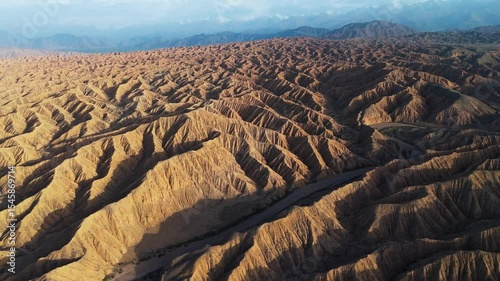
Aerial view of Ak Sai Canyons The Valley of Forgotten Rivers in Kyrgyzstan southern side of Issyl Kol lake , travel destination
Aerial view of Ak-Sai Canyons The Valley of Forgotten Rivers in Kyrgyzstan southern Issyl-Kol lake
Aerial view of Ak Sai Canyons The Valley of Forgotten Rivers in Kyrgyzstan southern side of Issyl Kol lake , travel destination
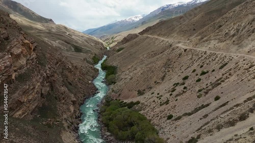
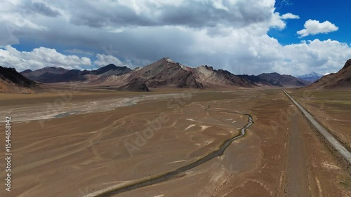
Aerial drone above Wakhan Valley Corridor, Pamir mountains , Badakhshan province of Afghanistan and Gorno-Badakhshan Autonomous Region of Tajikistan
Aerial Wakhan Valley Corridor, Pamir mountains , Badakhshan province of Afghanistan and Gorno-Badakhshan Autonomous Region of Tajikistan
Aerial drone of Wakhan Valley Corridor, Pamir mountains , Badakhshan province of Afghanistan and Gorno-Badakhshan Autonomous Region of Tajikistan
Aerial view of Wakhan Valley Corridor, Pamir mountains , Badakhshan province of Afghanistan and Gorno-Badakhshan Autonomous Region of Tajikistan
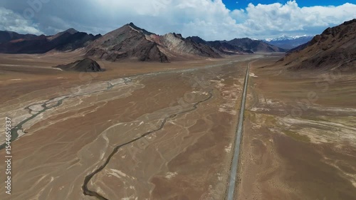
Tajikistan aerial footage of Pamir mountains range in Central Asia Pamir highway
Tajikistan aerial footage of Pamir mountains range in Central Asia with famous Pamir highway
Aerial view above Pamir Mountains in Tajikistan riding on famous Pamir highway scenic landscape
aerial drone motorcycle riding adventure into Kyrgyzstan valley mountains pass travel holiday explorer destination in remote wilderness
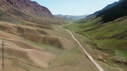
Aerial view of Kyrgyzstan lonely road into the mountain pass green Vally
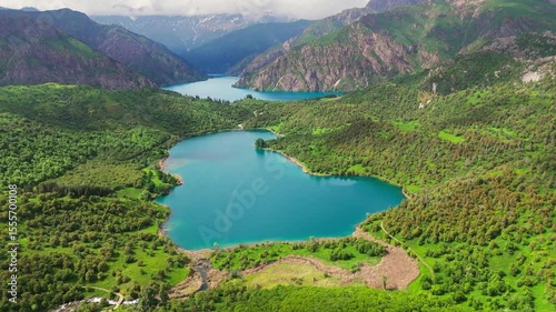
aerial view of sary chelek lake in Kyrgyzstan drone fly above scenic landscape with mountains in natural reserve
drone footage of sary chelek lake in Kyrgyzstan
Aerial top down of narrowed off road path green tree forest and blue pristine lake water
sary chelek lake in Kyrgyzstan drone aerial scenic nature landscape in central asia
drone fly above sary chelek lake in Kyrgyzstan
aerial above sary chelek lake in Kyrgyzstan scenic travel destination in Central Asia
sary chelek lake in Kyrgyzstan aerial drone central Asia
Aerial drone of Kyrgyzstan Toktogul lake largest water reservoir in Kyrgyz Republic and Central Asia
Aerial of Kyrgyzstan Toktogul lake largest water reservoir in Kyrgyz Republic and Central Asia
Aerial view of Kyrgyzstan Toktogul lake largest water reservoir in Kyrgyz Republic and Central Asia
Aerial top down Ak Sai Canyons The Valley of Forgotten Rivers in Kyrgyzstan Issyl Kol lake , rock pattern geologic formation
off road track inside the Ak Sai Canyons The Valley of Forgotten Rivers in Kyrgyzstan southern side of Issyl Kol lake , aerial drone
Aerial view Issyl Kol lake , travel destination in Kyrgyzstan at sunset
aerial view of Central Asia Pamir Highway adventure off road in Tajikistan scenic landscape
aerial view of scenic mountains valley of Kyrgyzstan
aerial drone motorcycle riding adventure into Kyrgyzstan valley mountains pass travel holiday explorer destination in remote wilderness
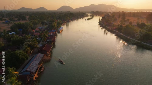
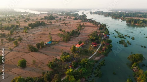
Aerial Laos at sunset of Don det and 4000 island Mekong river drone footage travel destination
Aerial Laos at sunset of Don det and 4000 island Mekong river drone footage travel destination
Monk stone valley park in Creel Chihuahua Mexico travel destination aerial drone
Aerial Laos sunset of Don det and 4000 islands Mekong river travel holiday destination
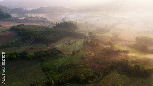
Aerial Fairy tale foggy morning forest with mystical sunlight drone woodland dreamy landscape
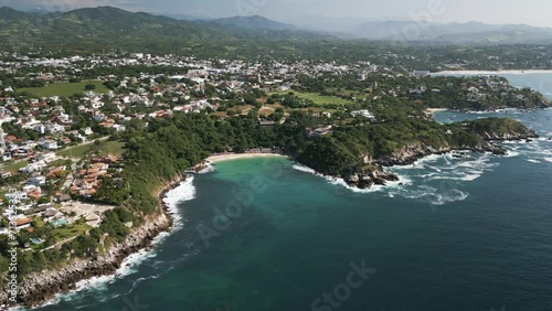
Aerial puerto escondido Mexico Oaxaca Surf travel destination drone coastline
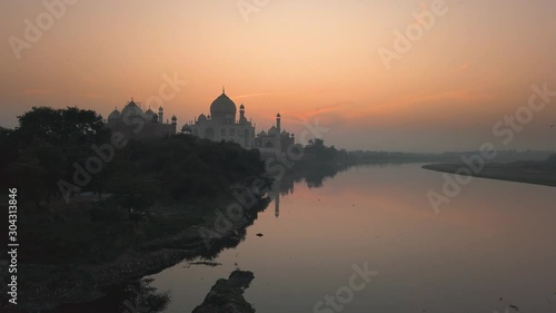
taj mahal in Agra UNESCO site in India view from Yamuna river during sunrise.
Alter do Chão brazil amazon river aerial view
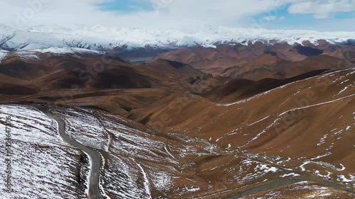
aerial view of Mount Everest Mountains range in tibet switchback road leading to base camp
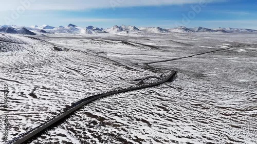
Aerial view of white snow covered mountains landscape with isolated road through in valley
aerial view of road passing through snow mountains range landscape leading to Everest Base Camp In Tibet
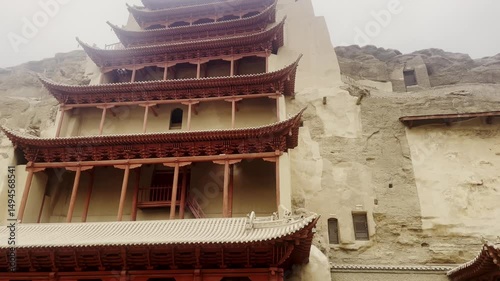
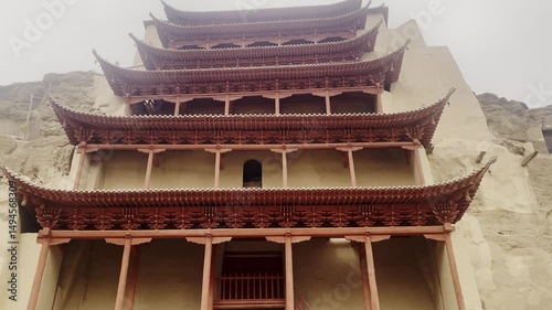
The Mogao Caves, Thousand Buddha Grottoes in Dunhuang, an oasis located on the Silk Road, in Gansu province, China
The Mogao Caves, Thousand Buddha Grottoes in Dunhuang, an oasis located on the Silk Road, in Gansu province, China
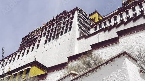
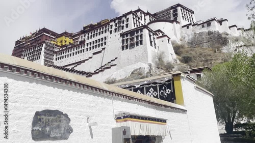
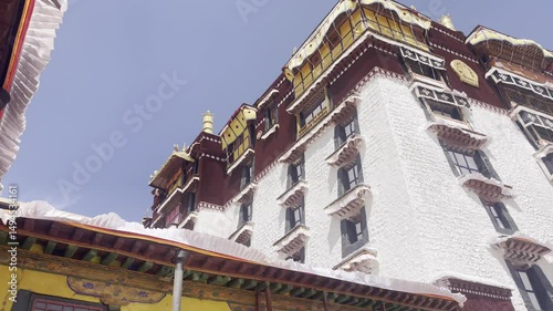
Potala Palace in Tibet Autonomous Region of China, Tibetan sovereign, the Dalai Lama, in the dzong-style, in Lhasa
Potala Palace in Tibet Autonomous Region of China, Tibetan sovereign, the Dalai Lama, in the dzong-style, in Lhasa lock up view
inside the Potala Palace in Tibet Autonomous Region of China, Tibetan sovereign, the Dalai Lama, in the dzong-style, in Lhasa
Potala Palace in Tibet Autonomous Region of China, Tibetan sovereign, the Dalai Lama, in the dzong-style, in Lhasa
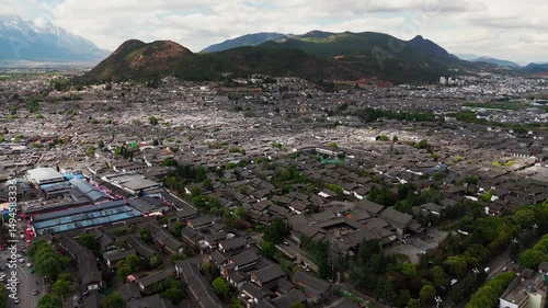
Aerial top down view of Dayan, the Old Town of Lijiang, in Yunnan, China, traditional Chinese architecture
Aerial view of Dayan, the Old Town of Lijiang, in Yunnan, China, traditional Chinese architecture and snow mountains at distance drone cityscape
Aerial view of Dayan, the Old Town of Lijiang, in Yunnan, China, drone fly above traditional Chinese architecture and snow mountains at distance
Aerial view of Dayan, the Old Town of Lijiang, in Yunnan, China, traditional Chinese architecture and snow mountains at distance
Aerial view of Dayan, the Old Town of Lijiang, in Yunnan, China drone footage
Aerial view of Dayan, the Old Town of Lijiang, in Yunnan, China, snow mountains at distance Unesco heritage
aerial view of Mount Everest Mountains range in tibet switchback road leading to base camp
Potala Palace in Tibet Autonomous Region of China, Tibetan sovereign, the Dalai Lama, in the dzong-style, in Lhasa detail of architecture
Aerial view of Lhasa Potala Palace square in Tibet Autonomous Region of China, Tibetan sovereign, the Dalai Lama, in the dzong-style, in Lhasa detail of architecture
adventure motorcycle riders off road in to the scenic mountains desert in Tibet
adventure motorcycle riders off road in to the scenic mountains desert
crew of adventure motorcycle riders off road in to the scenic mountains desert
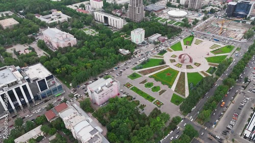
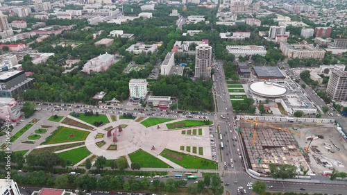
aerial top down Victory Square in the city of Bishkek, the capital of Kyrgyzstan
Aerial cityscape skyline view of Bishkek capital city of Kyrgyzstan
Aerial cityscape skyline view of Bishkek capital city of Kyrgyzstan with industrial factory
drone fly above the Victory Square in the city of Bishkek, the capital of Kyrgyzstan
Aerial top down view of Kyrgyzstan. Bishkek Central Mosque
drone fly above the Victory Square in the city of Bishkek, the capital of Kyrgyzstan
drone above Kyrgyzstan. Bishkek Central Mosque
milano city center duomo square cathedral with monument sunrise summer day time lapse
Aerial Laos at sunset of Don det and 4000 island Mekong river drone footage travel destination south east Asia
aerial of Vang Vieng town north of Vientiane, on the Nam Song River in Laos drone footage at sunset
Ban Ran Thai aerial view of Chinese village on Mae Hong Son province in Northern Thailand foggy misty mountains landscape with traditional boat on the lake
time lapse day to night Imperial City Entrance Night Time. Citadel Historical building and vietnamese landmark in the old city of hue Vietnam
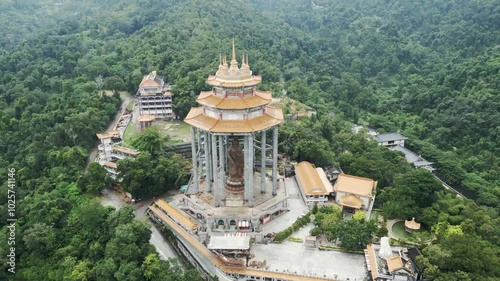
Aerial view of kek lok si temple in George Town hill in Penang island Malaysia
Aerial view of Favignana island Egadi archipelago Sicily mediterranean sea Italy
night sky time lapse milky way and stars trails over switzerland san bernardino pass alps
Mexico Baja California Sur cabo pulmo national park aerial drone
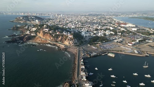
Drone fly above Mazatlan city in Mexico Sinaloa State revealing the port harbour
aerial of famous Basaseachi fall national park copper canyon Chihuahua state Mexico travel destination
Aerial top down of Playa De Los Muertos Puerto Vallarta mexico riviera Nayarit
Aerial of Todos Santos Baja California Sur Mexico beach sand dunes desert
Puerto Escondido Oaxaca Mexico Aerial coastline ocean surf spot destinations
Aerial footage of Isla mujeres in Cancun Mexico drone fly above Caribbean Sea
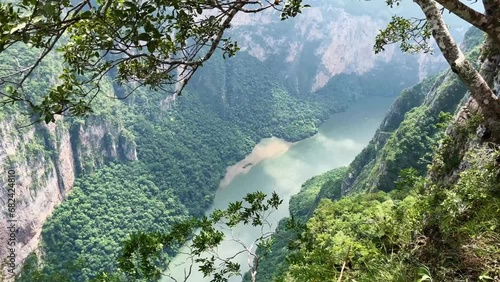
mexico chiapas canyon de sumidero travel destination near tuxtla Gutierrez
Puerto escondido Oaxaca mexico tropical beach ocean sea pacific coast
Taj Mahal the famous UNESCO site walking through framing marble arch with the local people and tourist at distance. Agra, India.
Aerial view of Sukhothai Thailand Si Satchanalai Historical Park, showcasing its ancient ruins and vibrant, strong colors
Aerial top down view of Sukhothai Thailand Si Satchanalai Historical Park, showcasing its ancient ruins and vibrant, strong colors
aerial view of scenic best road in Thailand the 1081 in Nan ragion province drone
aerial view of scenic best road in Thailand the 1081 in Nan ragion province drone
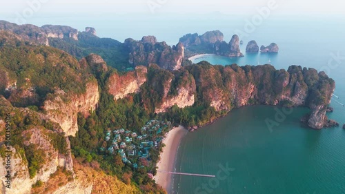
Drone sunset view of Krabi most famous beach Railay on the Andaman sea in Ao nang beach aerial footage of Thailand holiday destination with resort and cliff
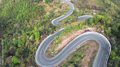
Aerial top down bending curve winding road path in the green forest
Aerial view of Sapan Village in Mueang Nan District, a hidden gem in Thailand rice field and river in mountains landscape
Aerial view of Sapan Village in Mueang Nan District, a hidden gem in Thailand rice field and river in mountains landscape
Aerial view of Sapan Village in Mueang Nan District, a hidden gem in Thailand rice field and river in mountains landscape
Aerial view of Sapan Village in Mueang Nan District, a hidden gem in Thailand rice field and river in mountains landscape
Thailand aerial view of buddhist sky temple in the province of Lampang, Wat Chalermprakiat
Thailand aerial view of buddhist sky temple in the province of Lampang, Wat Chalermprakiat
Thailand aerial view of buddhist sky temple in the province of Lampang, Wat Chalermprakiat
scenic aerial cliff sunset above sea in Krabi Thailand , drone of Railay beach Andaman sea in Ao nang beach drone footage luxury resort vacation holiday travel destination in Asia
Aerial view of Khao Sam Roi Yot National Park on the coast of Prachuap Khiri Khan Province right south of Hua Hin scenic river flowing in natural field
Aerial view of Khao Sam Roi Yot National Park on the coast of Prachuap Khiri Khan Province right south of Hua Hin