Login
Sign Up
Member Area
Login
Sign Up
English
Afrikaans formal
Afrikaans informal
Arabic
Azerbaijan
Brazilian
Bulgarian
Catalan
Chinese simplified
Chinese traditional
Croatian
Czech
Danish
Dutch
English
Estonian
Finnish
French
Georgian
German
Greek
Hebrew
Hungarian
Icelandic
Indonesian
Italian
Japanese
Latvian
Lithuanian
Malaysian
Norwegian
Persian
Polish
Portuguese
Romanian
Russian
Serbian
Slovakian
Slovenian
Spanish
Swedish
Thai
Turkish
Ukrainian
Vietnamese
Toggle navigation
VideotonStock
Your Shopping Cart is empty.
Files
Stock
Photo
Video
Special offer
Collections
Packages
Lightboxes
Licenses
Royalty free
Rights managed
Creative
Editorial
Items
Most downloaded
Featured
Most popular
New
Free
Categories
Browse categories
Site info
Site info
About
Support
Privacy Policy
Privacy Policy
FAQ
Contact Us
Contact Us
Terms and Conditions
Buyer Agreement
Seller Agreement
Customers
Users
Credits
Photographers
Boby Richards
0
Boby Richards
0
Videoton1
286
Search
Keywords:
Creator ID:
Type:
Photo
Illustration
Vector
Video
Template
3d
Categories:
Animals
Buildings and Architecture
Business
Drinks
The Environment
States of Mind
Food
Graphic Resources
Hobbies and Leisure
Industry
Landscapes
Lifestyle
People
Plants and Flowers
Culture and Religion
Science
Social Issues
Sports
Technology
Transport
Travel
News
Entertainment
Sport News
Languages:
Brazilan Portuguese - Brazil
English - Canada
French - Canada
Spanish - Mexico
English - United States
English - Belgium
French - Belgium
Dutch - Belgium
Czech - Czech Republic
English - Cyprus
Danish - Danmark
German - Germany
English - Estonia
Spanish - Spain
French - France
French - Marocco
English - Greece
English - Ireland
Italian - Italia
English - Latvia
English - Lithuania
German - Luxembourg
English - Luxembourg
French - Luxembourg
English - Hungary
English - Malta
Dutch - Nederlands
Bokmal Norwegian - Norway
German - Austria
Polish - Poland
Portuguese - Portugal
English - Romania
German - Switzerland
English - Slovenia
Slovakian - Slovakia
French - Switzerland
English - Finland
Swedish- Sweden
Italian - Switzerland
English - United Kingdom
English - Bulgaria
English - Australia
Japanese - Japan
Korean - South Korea
English - New Zealand
Russian - Russia
English - Ukrain
English - Thailand
Orientation:
All
Horizontal
Vertical
square
Color:
Model property release:
All
Yes
No
Duration Video:
All
Up to 10 seconds
Up to 20 seconds
Longer than 30 seconds
Results
(0)
Site
Getty/iStock
Bigstockphoto
Pixabay
Adobe Stock
Relevance
New
Most popular
Most downloaded
Undiscovered
12
24
36
48
96
Auto paging
Menu
This footage presents an aerial, top-down view of a hospital helipad marked with a red cross. The helipad is surrounded by buildings, green lawns, trees, and a parking area.
Animated weather map showing Atlantic wind patterns. Camera is static, focusing on a detailed wind flow visualization.
Overhead view of cars passing through a highway toll booth. Smooth traffic flow, clear day.
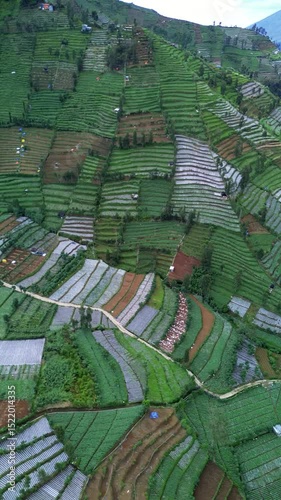
This footage shows an aerial view of green terraced farmland. The camera slowly pans to reveal houses nestled amongst the fields in a rural setting.
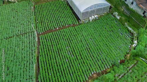
This footage showcases an aerial view of vibrant green vegetable fields, neatly arranged in rows, alongside a greenhouse in a rural setting. The camera slowly pans across the landscape.
This footage showcases an aerial view of vibrant green vegetable fields, neatly arranged in rows. A greenhouse stands nearby, with workers tending to the crops in a rural setting.
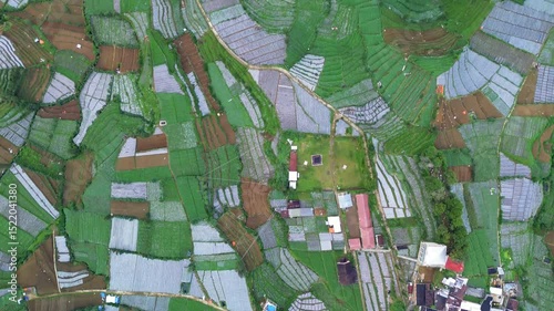
Aerial footage shows a top-down view of green vegetable fields, brown soil, houses, and roads in a rural area. The camera moves slowly.
This aerial footage showcases a patchwork of green vegetable fields and farmlands. The camera slowly pans across the landscape, revealing the textures and patterns of the rural area.
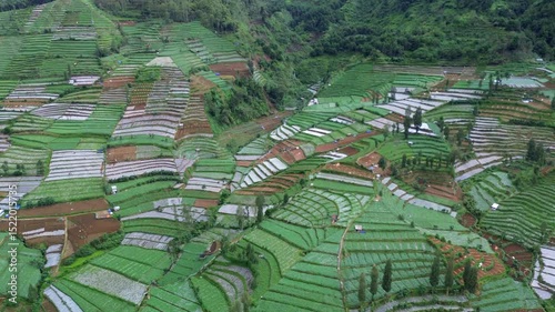
This footage shows an aerial view of terraced farmland. The fields are filled with green crops and brown soil, creating a patchwork pattern. The camera slowly pans across the landscape.
This footage shows an aerial view of terraced farmland. The camera is positioned directly above, capturing the geometric patterns and textures of the fields. The land is green and brown.
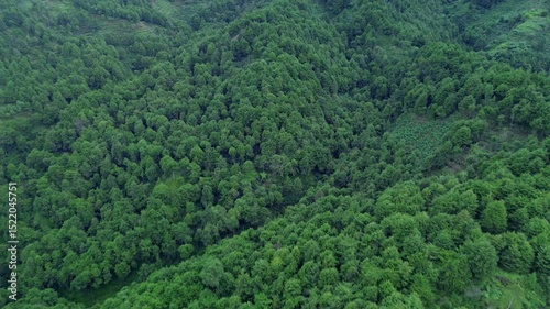
This footage showcases a dense green forest covering rolling hills, transitioning into terraced farmland. The camera slowly pans across the landscape, revealing the textures and patterns.
Aerial footage showcases vibrant green terraced fields nestled on a mountain slope. The camera pans down, revealing the intricate patterns and textures of the rural landscape.
This aerial footage showcases a dense, vibrant green forest bordering neatly terraced farmland on a hillside. The camera slowly pans across the landscape.
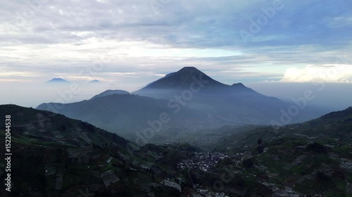
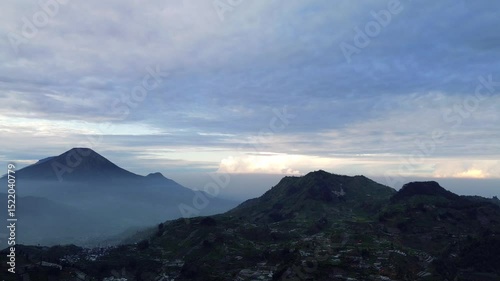
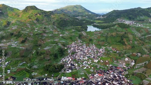
This footage shows a wide aerial shot of a mountain range with terraced fields and a small village nestled in the valley. The sky is partly cloudy.
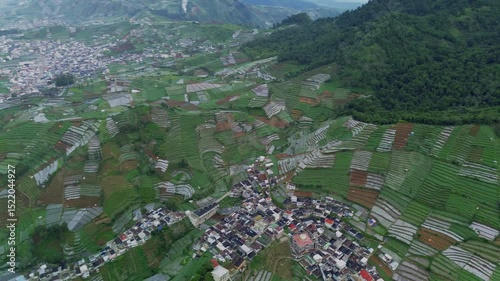
This aerial footage showcases a village nestled among lush, green terraced rice fields in the Dieng Plateau. The camera slowly pans across the landscape, revealing the intricate patterns of the fields
Aerial footage captures a mountain range with a village nestled below. Terraced fields cover the surrounding hillsides under a cloudy sky. Camera is static
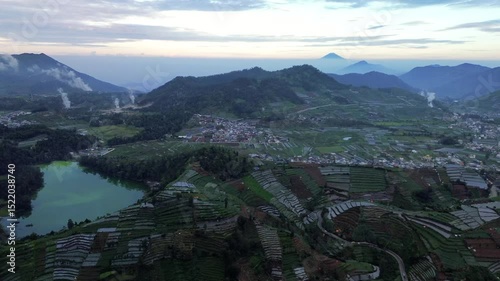
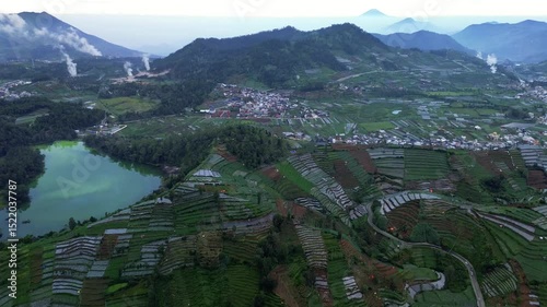
This aerial footage showcases green rice terraces, a small village, and a lake nestled in a mountainous region. The camera slowly pans across the landscape.
This aerial footage showcases Telaga Warna lake, lush rice terraces, and a village nestled in the Dieng Plateau, Indonesia. The camera slowly pans down, revealing the landscape.
This footage captures an aerial view of vibrant green rice terraces, a small village, and rolling hills in rural Indonesia. The camera slowly pans down, showcasing the landscape.
Aerial footage captures a village nestled among vibrant green rice terraces, a serene lake, and a majestic mountain backdrop in a rural Indonesian setting. Drone shot.
This aerial footage showcases a stunning mountain landscape in Indonesia. It features lush green rice terraces, a small village nestled in the valley, and a majestic mountain peak shrouded in mist.
This aerial footage showcases vibrant green rice terraces interspersed with brown patches. A dirt road winds through the fields, connecting small houses in a rural village.
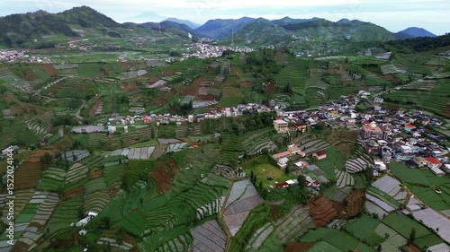
This footage shows an aerial view of terraced fields and a village in the Dieng Plateau, Central Java, Indonesia. The camera slowly pans across the landscape.
This aerial footage showcases terraced fields with varying shades of green and brown. A small village with houses and buildings is nestled beside the fields in Dieng, Indonesia.
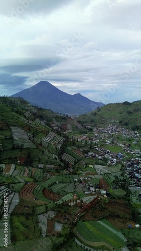
A wide shot of a mountain range under a cloudy sky. The sun is rising or setting, casting a soft light on the landscape. There is a small town in the valley.
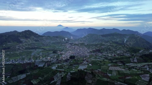
This aerial footage showcases a town nestled in a valley, surrounded by lush green terraced fields. Mountains rise in the background under a soft sunrise sky.
Drone footage captures an aerial view of the Dieng Plateau in Indonesia. Features a lake, terraced agricultural fields, a small town, and distant mountains under a hazy sky.
Footage shows a wide shot of Mount Sumbing with fog and clouds in the Dieng Plateau, Central Java, Indonesia. The camera is static.
This aerial footage showcases Telaga Warna lake surrounded by lush green terraced fields and mountains in Wonosobo, Central Java, Indonesia. The camera slowly pans across the landscape.
This aerial footage showcases terraced farms, a lake with greenish water, and a village nestled in the Dieng Plateau, Central Java, Indonesia. Mountains visible in the background.
Aerial footage shows a village in Dieng Plateau, Central Java, Indonesia. The shot includes mountains, terraced fields, and houses. The camera slowly zooms out.
This aerial footage showcases lush green rice terraces, a serene lake, and majestic mountains under a soft sunrise sky in Indonesia. A winding road cuts through the landscape.
This aerial footage captures a vast landscape of terraced rice fields, a winding road, a small lake, and majestic mountains under a soft, early morning light in Indonesia.
This footage shows a high-angle view of vibrant green vegetable terraces. The camera slowly pans across the landscape, revealing neatly arranged rows of crops in a rural setting.
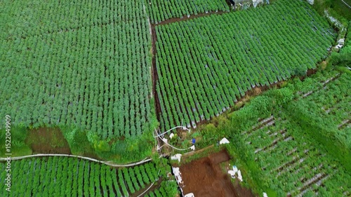
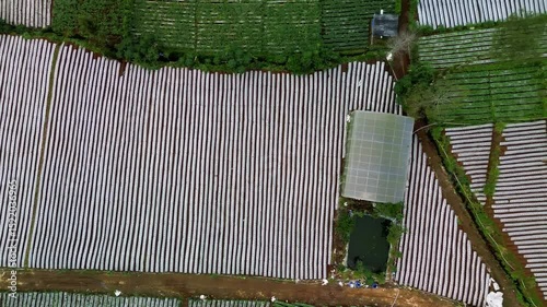
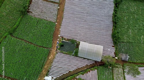
Aerial footage shows a top-down view of agricultural land. Features include rows of plastic mulch, a greenhouse, and a small pond. The camera slowly pans across the landscape.
Aerial footage shows a patchwork of agricultural land. Green plants and rows covered in white plastic mulch create a striped pattern. A greenhouse and small pond are also visible.
Aerial footage shows a village nestled among vibrant green terraced fields on a hillside. The camera slowly pans across the landscape, revealing the intricate patterns of agriculture.
This footage shows an aerial view of farmland. Rows of green crops are interspersed with sections covered in white plastic mulch. The camera slowly zooms out, revealing more of the landscape.
This footage showcases an aerial view of a village nestled among terraced fields, a lake, and rolling green mountains under a cloudy sky. The camera slowly pans to the left.
Drone shot of a village nestled amongst vibrant green terraced rice paddies in Central Java, Indonesia. The camera slowly pans across the landscape.
This footage captures an aerial shot of a village nestled among green rice terraces, with mountains and a lake in the background. The camera slowly pans across the landscape.
This footage shows an aerial view of a village nestled among terraced farmlands on a hillside. The village features colorful houses and a mosque with a golden dome.
This aerial footage showcases a valley with terraced rice fields, a small village with houses, and distant mountains under a cloudy sky. The camera slowly pans to the left.
Aerial footage captures a village nestled among terraced farmlands. A mosque with a golden dome stands out. The camera pans slowly, showcasing the landscape.
This footage showcases a wide aerial shot of vibrant green terraced rice fields nestled in a mountainous region. Small houses are visible among the fields. The camera slowly pans across the landscape.
This footage captures an aerial view of terraced fields and a small village in Central Java. The camera slowly pans across the landscape, revealing the intricate patterns of the fields.
This aerial footage showcases vibrant green terraced vegetable fields in Indonesia. The camera slowly pans across the landscape, revealing the intricate patterns of agriculture.
This footage captures a high-angle view of terraced farmlands on a hillside. The landscape features vibrant green vegetation, trees, and cultivated plots. The camera is static.
This footage showcases a high-angle view of terraced fields, a small village, and a majestic mountain under a cloudy sky in Indonesia. The camera is static.
This footage showcases a high-angle view of terraced farmlands on a hillside. The landscape features vibrant green fields, winding paths, and scattered structures. The camera remains static.
This footage shows an aerial view of terraced fields and a small village nestled in a mountain valley. The camera slowly pans down, revealing the patterns of the fields.
Close-up animation of a stock market data chart. Numbers and graphs fluctuate dynamically.
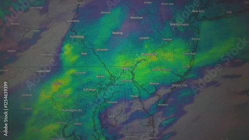
Animated weather map showing Mid-Atlantic region, color-coded precipitation. Static camera view.
Animated weather map showing precipitation over Maine and New Brunswick. Static camera, map view.
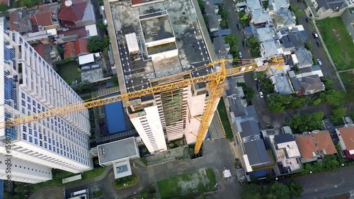
Footage shows a tall building under construction, featuring a yellow crane. The scene is set against a blue sky in an urban area with houses and buildings.
This footage shows a high-angle view of a tall building under construction. A yellow crane is visible on the side of the building. The building is mostly gray and white.
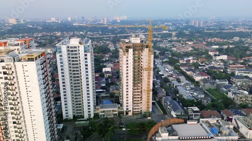
Aerial shot of a construction site in Jakarta, Indonesia. Features a tall building under construction with a yellow crane, surrounded by houses and apartment buildings. Camera moves slowly.
A close-up shot of a weather radar map. Taiwan is prominently displayed with blue and green areas indicating rain. Surrounding areas and city names are visible.
Footage showcases a yellow construction crane jib extending over a densely populated area with a cityscape in the background during sunset.
Close up shot of a weather radar screen displaying a map of the United States with storms moving across the south-central region. The camera is static.
Footage shows a yellow construction crane against a cityscape at dusk. An airplane flies in the distance. View from a high building, overlooking houses and skyscrapers.
Footage shows a yellow construction crane extending over a residential area with a distant cityscape. The sky is clear with soft sunset colors.
This footage shows a high-rise building under construction with a yellow crane. The camera pans down, revealing the cityscape with houses and other buildings.
Footage shows tall apartment buildings, one under construction with a yellow crane. The camera pans slightly over a cityscape with houses and trees in the background.
This footage shows an aerial view of Jakarta, Indonesia. Features apartment buildings, a construction site, and a residential neighborhood. The camera pans slightly.
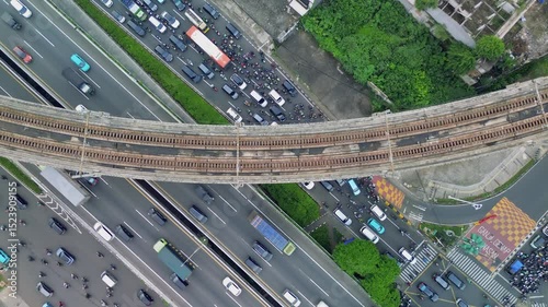
Overhead shot of a train crossing a bridge over a busy highway with cars and buses in Jakarta, Indonesia. Green foliage and buildings are visible.
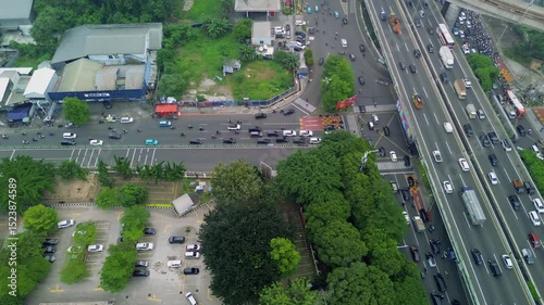
Aerial shot of a busy highway in Jakarta, Indonesia. Cars, trucks, and motorcycles are stuck in heavy traffic. An old train track runs overhead.
This aerial footage shows heavy traffic on a Jakarta highway. Cars, trucks, and motorcycles are moving along the road. There are trees and buildings visible in the surrounding area.
Aerial footage shows a road with cars moving alongside a dense green forest. The camera angle is top-down, providing a clear view of the road and the surrounding trees.
Aerial footage shows a road lined with trees on both sides. A car and motorbikes are seen moving along the road amidst lush green surroundings.
This aerial footage showcases a road winding through a vibrant green landscape. Cars and motorbikes travel along the road, bordered by trees and dense foliage. The camera remains static.
Footage shows a wide shot of Sikidang Crater with a wooden bridge, green vegetation, and a cloudy sky. Steam rises from the crater on the hillside.
Drone footage captures cars moving along a road bordered by trees and dense green vegetation. The camera angle is directly overhead, providing a bird's-eye perspective of the scene.
This footage shows an aerial view of a road lined with trees, next to a dense forest. Cars and motorcycles can be seen driving on the road. The camera is static.
Footage shows a geothermal area with steam venting from the ground. There is a wooden walkway, people walking, and a green hillside with trees. Cloudy sky above.
This footage shows a person's legs and feet walking across a wooden bridge. The camera angle is low, focusing on the bridge and the person's movement. Lush green vegetation surrounds the bridge.
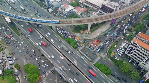
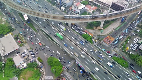
This aerial footage captures heavy traffic on a Jakarta highway. Cars, trucks, and motorcycles navigate the roads, with a train passing on an overpass above.
This aerial footage shows heavy traffic in Jakarta, Indonesia. Cars, buses, and motorcycles navigate the roads, with a train crossing over on a bridge. The shot is taken from above.
An aerial shot shows heavy traffic on a Jakarta highway. A train crosses overhead on a railway bridge. Buildings and greenery surround the busy road.
Footage shows a volcanic crater with steaming fumaroles and colorful sulfur deposits. The camera pans across the rocky landscape with sparse vegetation on a cloudy day.
Aerial footage shows Jakarta's urban landscape with buildings, a highway with traffic, and an elevated train track. Shot from above, capturing the city's density and infrastructure.
Footage shows a steaming crater lake with green water, surrounded by volcanic rock and vegetation. Mist rises from the water, obscuring the background of mountains and cloudy sky.
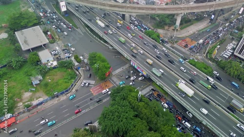
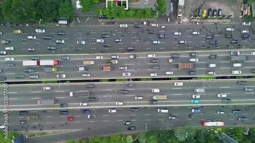
This aerial footage shows a top-down view of a busy highway in Jakarta, Indonesia. Cars, trucks, and motorcycles are seen navigating the congested roads amidst green trees.
This aerial footage showcases heavy traffic on a multi-lane highway in Jakarta, Indonesia. The shot is taken from directly above, providing a clear view of the cars, trucks, and motorcycles.
An aerial shot shows heavy traffic on a Jakarta highway. Cars, trucks, and buses move along multiple lanes. Elevated train tracks run parallel to the road.
This footage captures a top-down view of a bustling highway in Jakarta. Cars, trucks, and motorbikes navigate the multi-lane road amidst lush greenery on the sides.
This aerial footage shows a busy highway in Jakarta, Indonesia. Cars, trucks, buses, and motorcycles are seen moving along the road, with a train track running parallel.
This footage shows a top-down view of a busy highway in Jakarta. Cars, buses, and motorcycles are seen moving along the multiple lanes, with greenery and buildings on either side.
This aerial footage captures heavy traffic on a multi-lane highway with a railway track crossing overhead. Cars, trucks, and motorcycles are seen moving along the road in Jakarta, Indonesia.
This aerial footage shows a busy highway with cars, trucks, and buses. A train passes on an elevated track. Shot in Jakarta, Indonesia, the footage offers a top-down perspective.
This aerial footage showcases heavy traffic flow on a wide highway. The scene features cars, trucks, buses, and motorcycles moving along multiple lanes, surrounded by green trees.
Aerial footage captures heavy traffic on a Jakarta highway, featuring cars, motorcycles, an overpass, buildings, and green trees. The camera pans slowly showing the city landscape.
This aerial footage showcases a bustling highway in Jakarta, Indonesia. The scene includes cars, trucks, motorcycles, buildings, trees, and a parking lot. The camera slowly pans across the landscape.
This aerial footage shows heavy traffic on a Jakarta highway, with a train overpass above. The shot includes cars, buses, trucks, and motorcycles amidst a cityscape backdrop.
Aerial footage shows heavy traffic on a multi-lane highway with an overpass in Jakarta, Indonesia. Cars, trucks, and motorcycles move slowly through the congested roads.
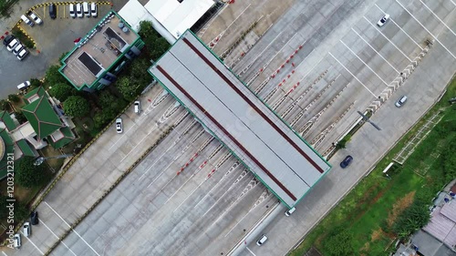
Overhead drone shot of a highway toll booth with cars entering and exiting. Clear view of lanes and infrastructure.
Vertical video footage of a tall white building exterior with balconies. Camera looks straight up.
Close-up footage of a weather map showing the Northeast USA. A finger points at a weather system.
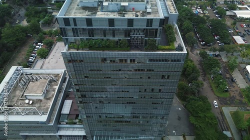
Drone footage of a tall modern office building, surrounded by parking lots and lush green trees. High-rise cityscape view.
Drone footage of a modern office complex, surrounded by lush greenery and parking lots. Shows two buildings and surrounding area.