Login
Sign Up
Member Area
Login
Sign Up
English
Afrikaans formal
Afrikaans informal
Arabic
Azerbaijan
Brazilian
Bulgarian
Catalan
Chinese simplified
Chinese traditional
Croatian
Czech
Danish
Dutch
English
Estonian
Finnish
French
Georgian
German
Greek
Hebrew
Hungarian
Icelandic
Indonesian
Italian
Japanese
Latvian
Lithuanian
Malaysian
Norwegian
Persian
Polish
Portuguese
Romanian
Russian
Serbian
Slovakian
Slovenian
Spanish
Swedish
Thai
Turkish
Ukrainian
Vietnamese
Toggle navigation
VideotonStock
Your Shopping Cart is empty.
Files
Stock
Photo
Video
Special offer
Collections
Packages
Lightboxes
Licenses
Royalty free
Rights managed
Creative
Editorial
Items
Most downloaded
Featured
Most popular
New
Free
Categories
Browse categories
Site info
Site info
About
Support
Privacy Policy
Privacy Policy
FAQ
Contact Us
Contact Us
Terms and Conditions
Buyer Agreement
Seller Agreement
Customers
Users
Credits
Photographers
Boby Richards
0
Boby Richards
0
Videoton1
286
Search
Keywords:
Creator ID:
Type:
Photo
Illustration
Vector
Video
Template
3d
Categories:
Animals
Buildings and Architecture
Business
Drinks
The Environment
States of Mind
Food
Graphic Resources
Hobbies and Leisure
Industry
Landscapes
Lifestyle
People
Plants and Flowers
Culture and Religion
Science
Social Issues
Sports
Technology
Transport
Travel
News
Entertainment
Sport News
Languages:
Brazilan Portuguese - Brazil
English - Canada
French - Canada
Spanish - Mexico
English - United States
English - Belgium
French - Belgium
Dutch - Belgium
Czech - Czech Republic
English - Cyprus
Danish - Danmark
German - Germany
English - Estonia
Spanish - Spain
French - France
French - Marocco
English - Greece
English - Ireland
Italian - Italia
English - Latvia
English - Lithuania
German - Luxembourg
English - Luxembourg
French - Luxembourg
English - Hungary
English - Malta
Dutch - Nederlands
Bokmal Norwegian - Norway
German - Austria
Polish - Poland
Portuguese - Portugal
English - Romania
German - Switzerland
English - Slovenia
Slovakian - Slovakia
French - Switzerland
English - Finland
Swedish- Sweden
Italian - Switzerland
English - United Kingdom
English - Bulgaria
English - Australia
Japanese - Japan
Korean - South Korea
English - New Zealand
Russian - Russia
English - Ukrain
English - Thailand
Orientation:
All
Horizontal
Vertical
square
Color:
Model property release:
All
Yes
No
Duration Video:
All
Up to 10 seconds
Up to 20 seconds
Longer than 30 seconds
Results
(0)
Site
Getty/iStock
Bigstockphoto
Pixabay
Adobe Stock
Relevance
New
Most popular
Most downloaded
Undiscovered
12
24
36
48
96
Auto paging
Menu
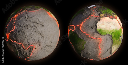
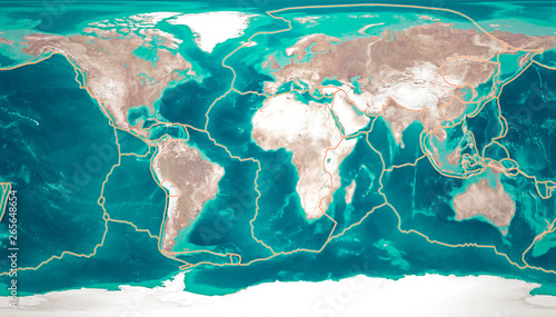
Earth's fault lines between tectonic plates
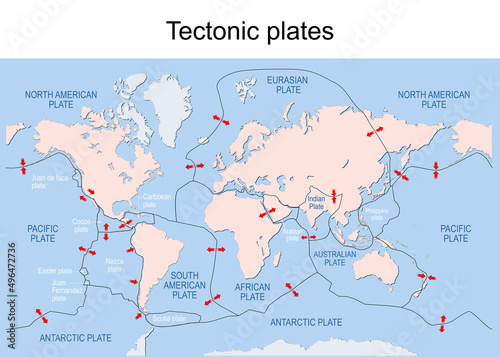
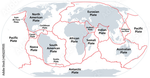
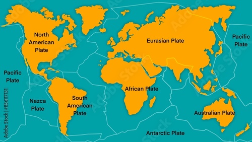
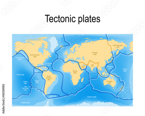
Map of Earth's principal tectonic plates.
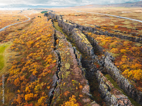
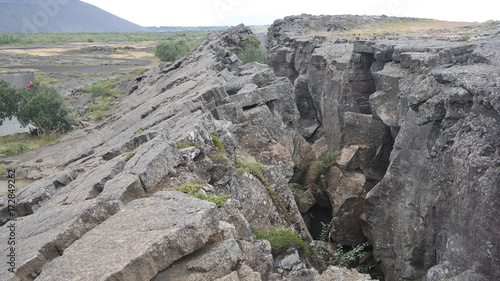
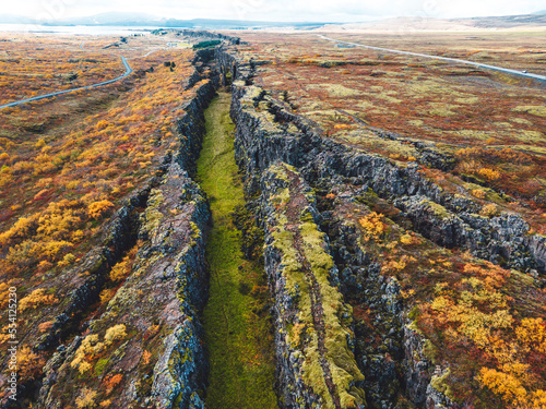
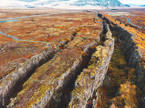
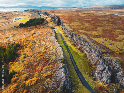
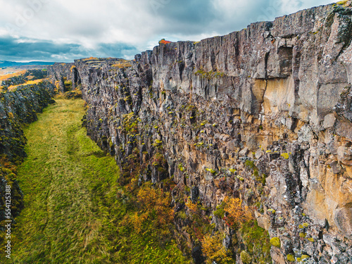
Thingvellir, Pingvellir canyon, two tectonic plates collide
The Eurasian and North American tectonic plates - Thingvellir National Park - Iceland
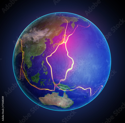
Global tectonic plate boundaries
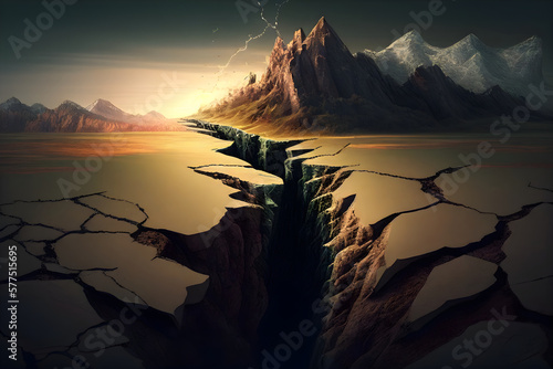
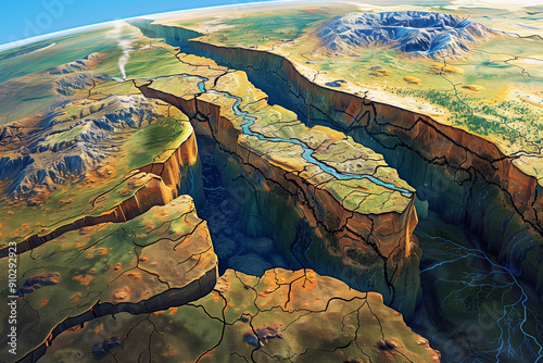
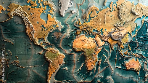
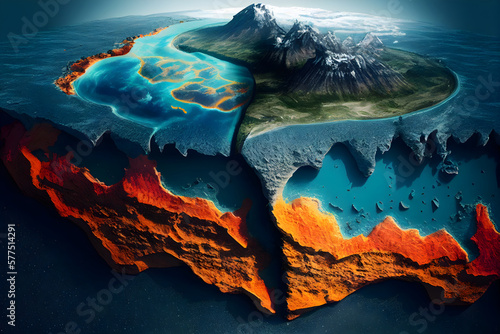
Fractured Earth: A Digital Depiction of Planetary Vulnerability
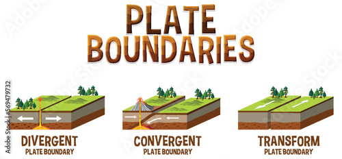
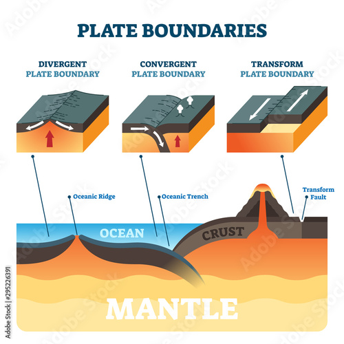
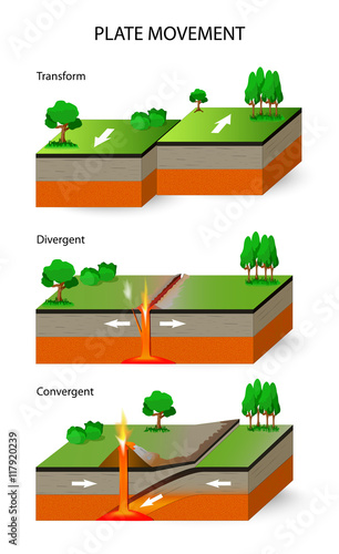
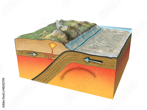
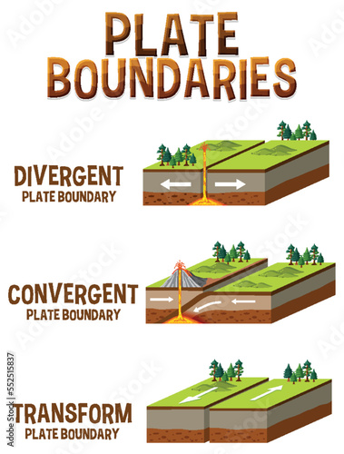
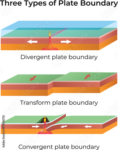
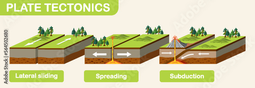
Three types of tectonic boundaries
Two tectonic plares, the North American and the Eurasian plates, are drifting apart
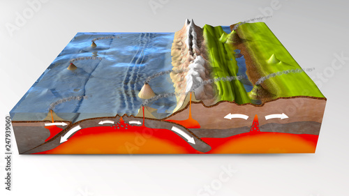
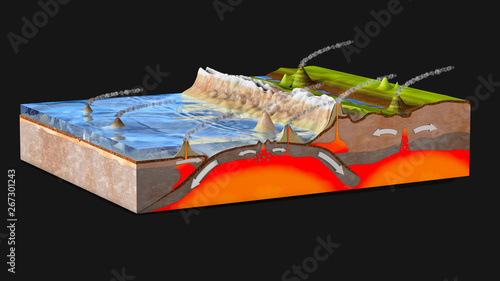
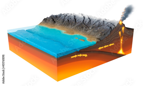
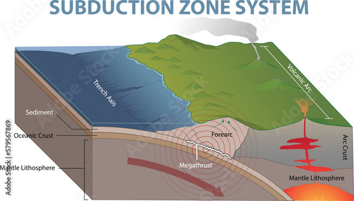
3d illustration of a scientific ground cross-section to explain subduction and plate tectonics with labels
Plate boundaries vector illustration. Labeled tectonic movement comparison.
Tectonic plates move constantly, making new areas of ocean floor, building mountains, causing earthquakes, and creating volcanoes. 3d rendering. Map. Element of this image are furnished by Nasa
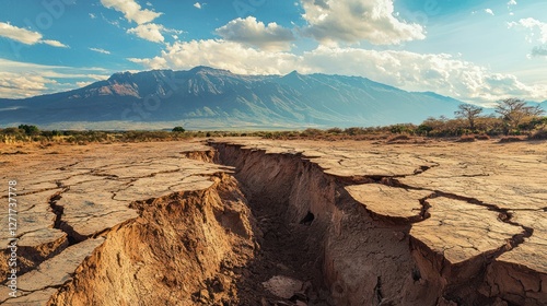
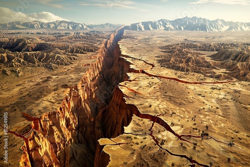
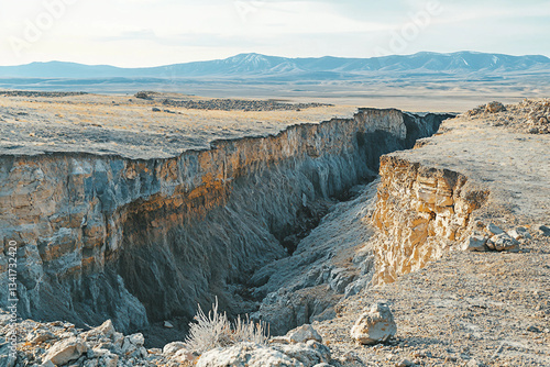
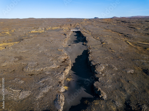
A photo of a rift valley formed by divergent boundary tectonic movements, with cracked earth and visible fissures.
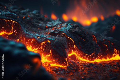
Dramatic Volcanic Landscape with Molten Lava Flowing across Rugged Terrain
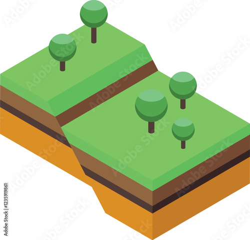
Earthquake is splitting the ground and showing soil layers, an isometric view of natural disaster
criss-cross fault line on the earth
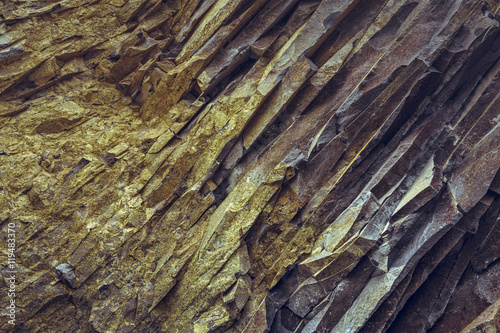
Closeup of tectonic basalt rock layers surface. Rock backgrounds and textures.
Tectonic plate shift and tectonic fault concept. AI generated
A vibrant digital illustration of Earth highlighting tectonic plates and geological features in neon colors.
massive earthquake tectonic plate shift huge ocean sea water turbulent tsunami power danger seismic event natural disaster environment dangerous
Tectonic plate boundary, Mid-Atlantic Ridge view, underwater crevices, geological details
Earth's fault lines between tectonic plates
Tectonic Plates. Plate movement
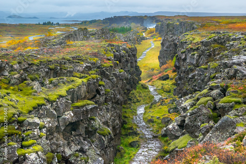
The only place on Earth where two tectonic plates meet on the Earth surface visible to the eye - Thingvellir National Park
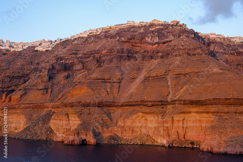
Pamoramic view of the caldera in Santorini
Abstract cracked earth double exposure concept of earthquakes and natural disaster
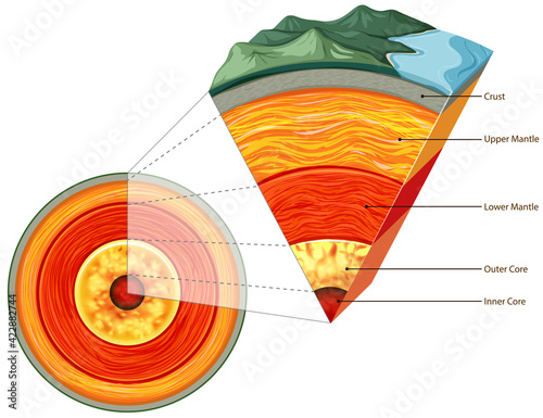
Earth's Core: A Geological Cross Section - Illustrative cutaway of Earth's interior, showcasing molten core, mantle layers, and crust. Symbolizing geology, heat, energy, structure
Three types of tectonic boundaries
A tectonic plate boundary showing an earthquake fault line, white background.
Aerial view of Earth with glowing tectonic plates, set against a starry background. The video captures a cosmic, futuristic style. Live desktop wallpaper.
An earthquake epicenter map showing tectonic plate boundaries and recent seismic activity,
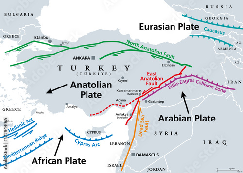
Anatolian Plate tectonics, gray map. Most of the country of Turkey is located on the Anatolian continental tectonic plate, separated from Eurasian and Arabian Plate by North and East Anatolian Fault.
A geological diagram illustrating plate boundaries and tectonic plate movements beneath Earth's surface.
A massive crack splitting through the earth after a devastating earthquake
World Map Fragmentation: Global Disintegration, Tectonic Shift, and Continental Drift with Glowing Fractures
Geological fault lines or tectonic plates shifting beneath the Earth's surface, coating seismic activity and triggering earthquakes.
Erupting volcano with smoke and ash depicted in detailed engraving art. Vector retro hand drawn illustration
Plates tectonic
Dynamic illustration of tectonic plates shifting and generating earthquakes. Tectonic. Illustration
Dramatic glowing crack on Earth surface showing intense heat and destruction under dark landscape, powerful natural disaster on planet with fiery volcanic fissure and tectonic activity
Volcanic Eruption in Full Force
Earthquake Icon
A highly detailed 3D-rendered earthquake simulation, showing tectonic plates shifting
Dramatic view of two tectonic plates meeting in Thingvellir National Park, Iceland
Fira village at sunset in Santorini
Illustration of tectonic plates shifting, with a visible fault line and earth's layers highlighted, demonstrating the process of continental drift and seismic activity.
Roadway severely cracked after earthquake. Natural disaster aftermath, collapsed asphalt, smoke in background. Urban street destroyed, fractured ground from shaking. Concept of destruction, seismic
Three types of tectonic boundaries
Tectonic Plate Simulation Showcasing Earth's Dynamic Geology and Crustal Forces
Generative AI Illustration of Geological Faults and Tectonic Processes in Arid Landscape
An earthquake epicenter map showing tectonic plate boundaries and recent seismic activity,
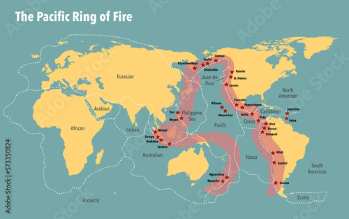
Map of the pacific ring of fire including the tectonic plates
Principal tectonic plates of the Earth, gray map. The sixteen major pieces of crust and uppermost mantle of the Earth, called the lithosphere, and consisting of oceanic and continental crust. Vector.
Cross-section illustration of volcanic activity and subterranean layers.
Map of Earth's principal tectonic plates, Tectonic Plate World Map Concept Design, The sixteen major pieces of crust and uppermost mantle of the Earth, called the lithosphere, Earth's surface, geology
scientific ground cross-section to explain subduction and plate tectonics - 3d illustration
Three Types of Plate Boundaries Design Vector Illustration
Colorful Geological Terrain
Aerial view of a vast, cracked desert landscape with dust clouds, capturing a dramatic and cinematic style, reminiscent of a video game scene. Live desktop wallpaper.
Exploring the Tectonic Mysteries of Our Planet - Earth Sciences Unveiled
Active volcano with lava eruption, tectonic plates of the Earth in section. Vector animation in isometry in flat art style
Abyssal Geothermal Vent Emanating Superheated Liquid in the Deep Ocean Realm
A dramatic underwater fault line with visible cracks and blue ocean water during an earthquake
Aerial view of Thingvellir National Park, where two tectonic plates meet
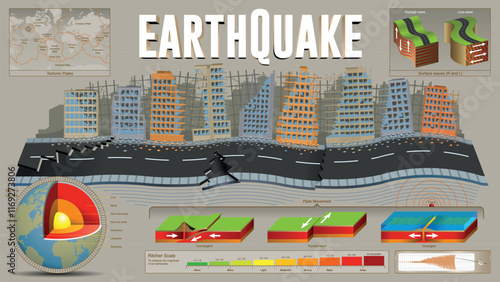
Earthquake infographic. Destroyed buildings and fragmented street surrounded by plate tectonic shift data against grey background
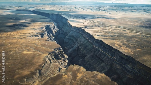
Aerial view of a massive tectonic fault line cutting through a barren desert landscape, with jagged rocks and deep crevices highlighting the power of geological forces.
Convergent tectonic plate boundary, illustration
earthquake causing large fault in ground, tectonic plates
Three types of tectonic boundaries
Earthquakes Regions along tectonic plate boundaries
Female photographer enjoying scenery, rural nature
A massive fissure in the earth demonstrates significant tectonic activity, revealing cracks in the parched terrain below.
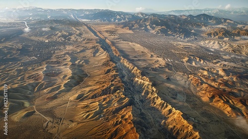
An aerial view of the San Andreas Fault, illustrating tectonic plate interaction,
A stunning photo of volcanic activity along a tectonic plate boundary, with eruptions and lava flows.
closeup image of glowing molten lava, generative ai
Tectonic plate movement showing rock deformation at molecular level
A powerful earthquake damage. Concept of the environment, earthquakes
Divergent tectonic plate boundary, illustration. Seafloor. Illustration
Cross-section the Earth's crust with layers rock, minerals, and tectonic plates
illustration of subduction zone diagram
Aerial of the bridge connecting the north american and eurasian tectonic plates at Reykjanes, showcasing the dramatic rift between two major geological boundaries
Dramatic underwater geological formation with imposing rock walls and deep trench
Generative AI Illustration of Geological Faults and Tectonic Processes in Arid Landscape
cracked ground surface showing tectonic fault lines
tectonic plates. map
Steep rock wall, the ending of Atlantic tectonic plate in Thingvellir National Park
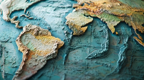
Global Earth map with ocean floor topography and detailed land surface, illustration of continents, seas, and tectonic plates model
Tectonic plate shift and tectonic fault concept. AI generated
Tectonic Plate Boundaries and Earthquake Distribution:A Geospatial Visualization
Types of tectonic plate boundaries
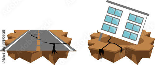
Earthquake disaster damage illustration road building cracks destruction natural calamity seismic activity 100 editable stock vector illustration
Earth's fault lines between tectonic plates
A detailed diagram showing the boundaries and movements of tectonic plates,
Village on the island of Santorini seen from the caldera
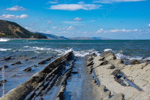
Tectonic shoreline near Castlepoint, New Zealand. Rocks tilted by natures earthquakes and plate movement.
National Park of Thingvellir in Iceland. It is the site of a rift valley that marks the crest of the Mid-Atlantic Ridge. Tectonic plate fault between two roads.
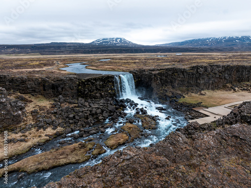
Aerial panorama of Oxarafoss waterfalls in Thingvellir National Park, Iceland, featuring the scenic Oxara River and the unique landscape created by the tectonic plates of America and Eurasia.
Shot of transcontinental rift and tectonic plates in Iceland
Geology, layers, plates, tectonics section. Schematic abstract view of the bowels of the earth using the example of various landscapes of desert canyon mountains, rivers, sea, cliff shore
Thingvellir rocks in Golden Circle of Iceland
Isolated earth plates tectonic